|
|
| There are no recent reports for this station. |
|
|
|
|
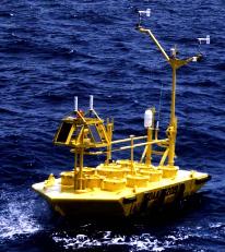
| Owned and maintained by: | National Data Buoy Center |
| Station Lat, Lon: | 30.40N, 80.10W |
| Buoy type: | 6-meter NOMAD buoy |
| Station elevation: | sea level |
| Air temp height: | 4 m above site elevation |
| Anemometer height: | 5 m above site elevation |
| Barometer elevation: | sea level |
| Sea temp depth: | 1m below site elevation |
|
 |
| A marine forecast is not available for this station. |
| A detailed observation summary is not available for this station. |
| A detailed wave summary is not available for this station. |
| 41003 | 30.40N | 80.10W | |
| SECG1 | 30.80N | 80.32W | U.S. Navy Tower R4 GA |
| 41012 | 30.04N | 80.55W | St. Augustine, FL 40NM ENE of St Augustine, FL |
| SPAG1 | 31.38N | 80.57W | U.S. Navy Tower R2 GA |
| 41112 | 30.72N | 81.29W | Offshore Fernandina Beach, FL (132) |
| SJLF1 | 30.40N | 81.40W | St. John's Light |
| SKMG1 | 31.53N | 80.24W | U.S. Navy Tower M2R6 GA |
| SAUF1 | 29.86N | 81.26W | St. Augustine, FL |
| MYPF1 | 30.40N | 81.43W | 8720218 - Mayport (Bar Pilots Dock), FL |
| 41008 | 31.40N | 80.87W | GRAYS REEF - 40 NM Southeast of Savannah, GA |
| FRDF1 | 30.67N | 81.47W | 8720030 - Fernandina Beach, FL |
| GTXF1 | 29.66N | 81.22W | Guana Tolomato Matanzas Reserve, FL |
| GTQF1 | 29.67N | 81.26W | Pellicer Creek, Guan Tolomato Matanzas Reserve, FL |
| TYBG1 | 31.63N | 79.92W | U.S. Navy Tower R8 GA |
| 41005 | 31.70N | 79.70W | |
Data provided by National Data Buoy Center
|
