|
|
| There are no recent reports for this station. |
|
|
|
|
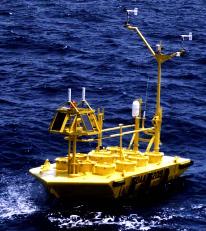
| Owned and maintained by: | National Data Buoy Center |
| Station Lat, Lon: | 28.20N, 80.10W |
| Buoy type: | 6-meter NOMAD buoy |
| Station elevation: | sea level |
| Air temp height: | 4 m above site elevation |
| Anemometer height: | 5 m above site elevation |
| Barometer elevation: | sea level |
| Sea temp depth: | 1m below site elevation |
|
 |
| A marine forecast is not available for this station. |
| A detailed observation summary is not available for this station. |
| A detailed wave summary is not available for this station. |
| 41011 | 28.20N | 80.10W | |
| 41009 | 28.50N | 80.17W | CANAVERAL 20 NM East of Cape Canaveral, FL |
| 41113 | 28.40N | 80.53W | Cape Canaveral Nearshore, FL (143) |
| TRDF1 | 28.42N | 80.59W | 8721604 - Trident Pier, FL |
| 41114 | 27.55N | 80.22W | Fort Pierce, FL (134) |
| SCIS1 | 28.85N | 79.70W | 8664941 - South Capers Island, SC |
| LKWF1 | 26.61N | 80.03W | Lake Worth, FL |
| 41010 | 28.95N | 78.47W | CANAVERAL EAST 120NM East of Cape Canaveral |
| GTXF1 | 29.66N | 81.22W | Guana Tolomato Matanzas Reserve, FL |
| GTQF1 | 29.67N | 81.26W | Pellicer Creek, Guan Tolomato Matanzas Reserve, FL |
| SPGF1 | 26.70N | 79.00W | Settlement Point, GBI |
| 41012 | 30.04N | 80.55W | St. Augustine, FL 40NM ENE of St Augustine, FL |
| SAUF1 | 29.86N | 81.26W | St. Augustine, FL |
| MCYF1 | 27.91N | 82.43W | 8726667 - McKay Bay Entrance, FL |
| ERTF1 | 27.92N | 82.44W | 8726669 - Berth 223 Met, FL |
Data provided by National Data Buoy Center
|
